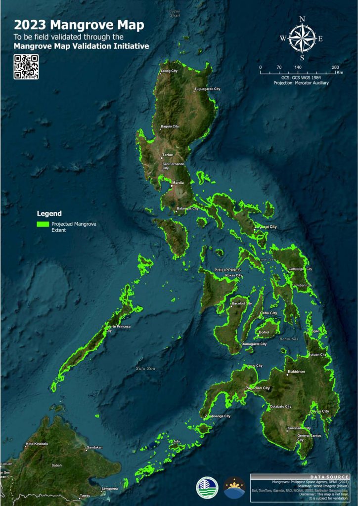
The Department of Environment and Natural Resources (DENR) has urged the public to take an active role in the rehabilitation and conservation of the country’s mangrove forests by helping validate on the ground the mangrove map created through satellite data.
The National Mangrove Map 2023, the satellite-derived map developed by the DENR and the Philippine Space Agency (PhilSA), will serve as the basis for making informed decisions and developing policies aimed at restoring and protecting Philippine mangroves.
Mangroves are productive salt-tolerant ecosystems that play a critical role in coastal protection, carbon sequestration, biodiversity conservation, poverty alleviation, and food security. They face a decline and are continually threatened due to human activities and natural disturbances.
Citing the need “to measure what we treasure” through the power of citizen science, DENR Secretary Maria Antonia Yulo Loyzaga called for a collaborative effort and urged everyone to take an active role in the mangrove initiative and the safeguarding of the country’s ecosystems.
“Amid the climate emergency and destruction of mangroves, everyone has the ability to make a difference by tracking and protecting our natural resources,” she said.
The initiative calls for the private and public sectors, including private individuals and organizations, to visit coastal barangays and verify the presence or absence of mangroves with the easy-to-use ODK Collect app available in the Google Play Store, or they can submit drone images of local mangroves to sdmad@philsa.gov.ph.
To get started, one can download the ODK Collect app, then scan the QR code from the e-manual (https://bit.ly/Mangrove2023Validation) for the step-by-step instructions.
The ODK Collect app provides easy-to-follow guidelines to collect data that will validate the presence or absence of mangroves in several spots within the same barangay, keeping a distance of 10 meters from the previous validation point.
Participants with drone equipment can opt for drone surveying and mapping over the ODK Collect app following the flight plan specified in the e-manual.
With over 600 sites and 30,000 validation points across the country as targets, the DENR aims to finalize the field validation of the mangrove map by June 2024. So far, the project has received less than five percent of the targeted submissions, underscoring the need for urgent action and increased participation by the public.
Validating the National Mangrove Map is vital to quantifying and determining the true value of the country’s natural resources contributing to climate and disaster risk resilience and sustainable development.
The initiative complies with Secretary Loyzaga’s directives to “measure what we treasure” to implement science-based and sustainable measures for managing the country’s natural resources. The DENR said the protection of the country’s critical ecosystems starts by establishing a national natural resource geospatial database as the physical basis for natural capital accounting system and development planning.###
Mangrove Map Validation Manual 2023 for ODK and /or drone survey: https://bit.ly/
Reel video demonstration of the mangrove map validation: https://bit.ly/
List of target sites for validation:
Luzon: https://bit.ly/
Visayas: https://bit.ly/
Mindanao: https://bit.ly/
For further questions and clarifications, please contact the Geospatial Database Office of the DENR at (02) 8920 4498, VOIP 1202, or via email at geospatial@denr.gov.ph.


